


Czick on the road / Chile / Torres del Paine – day hikes for every hiker


Patagonia. The place to go chasing your dreams. A place with breathtaking beauty, wild nature, and severe living conditions. One of the most beautiful places on Earth I've seen and probably the last place on Earth I'd want to live in.
Why's that? I'm spoiled by Slovenia... Patagonia is amazing, but nothing really grows there, it's windy all the time and you never know how the weather will change in the next minute. Still, nothing changes the fact, that a hiking trip to Patagonia should be on your bucket list.
No time to read it now? Pin it to read it later:
Planing trekking in Torres del Paine
We've managed to visit Patagonia in the summer – the best time to hike Torres del Paine. It was during our 15 months-long trip to South America and I was planning and postponing the trip to Torres del Paine to make it perfect and to get the most ideal weather conditions – unfortunately, the weather is the only thing that cannot be planned, especially in Patagonia.
Regardless of the summertime, at night we were freezing in our rented equipment, had no views for 3 days, and had to hike in the rain, strong wind and snow! I had 4 full-day hikes planned, but after coming from the first one completely soaked, frozen, exhausted and without any amazing pictures to soothe my soul, I gave up the rest.
I gave up my elaborate plan on hiking the W trek in Torres del Paine without having the camping booked and instead made a last-minute back up plan that was more relaxed, suited the weather we had and made me really happy. Because the third day, the sun came up and the mountains arose from the clouds, and we were charmed.
Patagonia is the last place I'd want to live in, but would come back to see this beauty without any hesitation, anytime! So if you plan to travel to Torres del Paine and are scared by the impossible weather, the heavy backpack you would have to carry on the W-trek, or you simply didn't manage to book your W-trek camping, keep reading to find out about the best day hikes in Torres del Paine.
Torres del Paine National Park hikes
Our 4 days itinerary for hiking in the Torres del Paine National Park covered almost the whole W trek (on the map, it looks like a lettter W). After arrival the first day, we went for a small hike to Salto Grande Waterfall. Then slept in the Lago Pehoe campsite and headed to the Mirador Torres the next day.
After another night in the Lago Pehoe campsite, we wanted to take the Pudeto catamaran ferry to cross the Pehoe lake, sleep in the Camping Paine Grande, where we have reserved 2 nights, and do the hikes to Mirador Frances and Mirador Glacier Grey. This way, most of the W trek would be covered and we would have just missed the second part.
Looking back, I wouldn't change a thing about the experience—but these days, I'd definitely opt for the comfort of having someone else handle the logistics. Instead of coordinating campsites, ferry schedules, and meal planning, I’d book a guided trek, let the experts handle the details, and simply enjoy the breathtaking views stress-free. And if guided tours aren’t your thing, consider a self-guided trek where all logistics and planning are taken care of—you just show up and hike!
#1 Hike to Salto Grande waterfall and Mirador Cuernos
- Difficulty: easy
- Length: 40 – 60 minutes of easy walk
The hike to Salto Grande and Mirador Cuernos was the first hike we did in Torres del Paine National park. After getting geared up in Puerto Natales, we've arrived at the park in an early afternoon and went to stretch our legs and test the terrain on this short hike.
The hike itself is not very demanding, the only hard thing was the unbelievably strong wind, that made walking extremely difficult. The forecast said 40 km/h with gusts as strong as 90 km/h. I was hoping that such strong wind would blow away all the clouds, but unfortunately, that didn't happen – on the contrary it had brought rain and snow clouds the next day.
To reach the Salto Grande waterfall we followed signs from the bus station and within 15 minutes reached the waterfall, which really is exceptionally beautiful. Despite the wind, we've decided to continue on the trail till Mirador Cuernos, and though we knew that there's no chance in seeing the tremendous Paine horns, we enjoyed the walk in nature and the company of cute but shy vicunas. Check the hike statistics, the map or download the GPS track here >>
#2 Hike to the Mirador Torres del Paine
- Difficulty: hard
- Length: 7 - 8 hours, 22km (both ways), over 1000 m elllevation gain
The hike to Mirador Torres del Paine was the one I was looking forward to the most. It's not an easy one, but the promise of the view at the famous towers and milky green lagoon under them was a great motivation.
The hike starts at the visitors' centre nearby hotel Torres, where we had to fill in a registration form, only then could hit the trail. First, it follows a grassy path and passes a few hanging bridges, then it slowly starts to rise.
Don't be fooled by the number of people that do this hike, it's not an easy one. In total, we made 21 km and gained over 1000 elevation meters. It took us altogether 7 hours, but usually, 8 – 9 hours are needed. The maximum elevation is 890m, so no worries about altitude sickness here. Check the hike statistics, the map or download the GPS track here >>
Unfortunately, during our hike, we saw nothing but fog. It was raining most of the time we hiked up, and when we were finishing the final stretch, it even started snowing. And it was in the middle of the summer!
Later we found out, that we were one of the last people who could finish the trail. Right after us, the park guards closed the path because it was too dangerous. And yes, walking down on the freshly fallen snow was very slippery.
#3 Hiking from Paine Grande campsite to the Mirador Frances
- Difficulty: hard
- Length: 7 - 8 hours, 20km (both ways), over 600 m elllevation gain
This hike was planned for the third day. We wanted to catch the 9:00 a.m. catamaran ferry to Paine Grande campsite, where we have managed to book 2 nights. The hike ot MIrador Frances is 20km long (both ways) and it could be also prolonged to Mirador Britanico (29 km both ways). Check the hike statistics, the map or download the GPS track of the Mirador Frances hike here >>
Because of the bad weather, we said we would decide in the morning whether we go on this hike or not. And we decided not to go. It was a hard decision to make. I was planning the hikes in Torres del Paine so long, and the thought of giving them up was not easy. But when we woke up and saw the sun coming through the clouds illuminating the peaks of the white mountains across the lake, but also the thick fog at the foot of the mountains – exactly where the hiking paths were, we knew that we would spend another day in the fog and rain and decided to stay in the sunny part of the park instead.
#4 Hiking from Paine Grande campsite to the Glacier Grey viewpoint
- Difficulty: medium
- Length: 8 hours, 22km (both ways), over 400 m elllevation gain
This hike in Torres del Paine was planned for the fourth day, but from reasons described above, we didn't go. It's a 22km hike (both ways) and usually, it's the last hike on the W trek. The Glacier Grey can be also seen from a far distance from the Viewpoint Vista al Glacier Grey, and that's what we eventually did instead of hiking the whole distance (described below). Check the hike statistics, the map or download the GPS track of Glacier Grey hike here >>
#5 A short walk from Explora Lodge to Salto Chico Falls
- Difficulty: easy
- Length: 20 – 40 minutes of easy walk
The Explora Lodge lies nearby the Lago Pehoe Campsite and there is a nice walk on wooden bridges around the Lodge with beautiful views at the lake and the mountains behind it. If you are cheeky enough, you will follow the wooden path across the access road to the Lodge, passing by their spa centre until you reach a small waterfall hidden behind the Lodge.
I'm not sure if the entry is allowed or not, but since there were no signs forbidding entry, we spent a good hour here slowly walking around and admiring the views, then continued towards the viewpoint Vista al Glacier Grey.
#6 Hike from Hotel Lago Grey to Vista al Glacier Grey or to Mirador Ferrier
- Difficulty: easy
- Length: 60 minutes of easy walk
It's a good 30 min car drive from Explore Lodge to the Hotel Lago Grey, which lies on the very right side of the Torres del Paine park. This area is quite touristic, and I'm not talking about backpackers. Most of the visitors go here to enjoy quite expensive boat tours on the Lago Grey all the way towards the Glacier Grey – something we were not willing to pay for.
There is a very nice alternative to the boat ride though, and that's the walk from the Hotel Lao Grey towards a small island with viewpoint Vista al Lago Grey. On Google maps it looks like this island is not accessible, but there is a big stripe of gravel connecting it to the park, so you can easily walk there and enjoy the views of the Glacier in the distance as well as the view at the big pieces of ice floating on the lake – some of them actually very close to the island. It's a very shot and easy 5km walk.
Alternatively you can also head to the Ferrier lookout, which is a steep 2hour hike that also starts at the Hotel Lago Grey. On the top, you will get an amazing view of the glacier and the lakes. Looking at the photos now, I couldn't be sadder we didn't do this hike. I found a GPS track you can follow here.
#7 Hiking from Laguna Azul to Laguna Cebolla
- Difficulty: medium
- Length: 3-4 hodiny, 16 km (both ways), 280 m ellevation gain
The hike from Laguna Azul and Laguna Cebolla is yet another hike we didn't do. Not because there was no time or weather for it, but simply because I didn't know about it. So I decided to include it at least in this article, as by looking at the photos, it looks amazing.
It's located on the east side of the park and it has a great view of the famous Torres towers. You can arrive by car to Laguna Azul and walk around, or prolong the hike to Laguna Cebolla. It's a 16 km hike that should take around 4 hours. I found a GPS track here and a great detailed description of the hike here.
From Day Hikes to a Full Patagonia Adventure
If the photos of our day hikes in Torres del Paine leave you craving more, why not dive into the full Patagonian experience? Imagine nine days of hiking, cycling, horseback riding, and even giving back through meaningful volunteering—all in the breathtaking landscapes of Chilean Patagonia. This 9-Day Women’s Adventure is designed for those who want to go beyond the trails and truly connect with nature, local communities, and like-minded adventurers. Ready to take your journey to the next level? Join the adventure here!
Torres del Paine camping – where to sleep?
Once you start reading a bit about visiting Torres del Paine, you'll find out that doing the W trek without having the camps booked at least a few months in advance is not possible. Though we met a French couple, who managed to book all needed camps just 2 weeks in advance, so nothing really is impossible. Before you give up, try contacting all the camping sites, and also read this guide to camping in Torres del Paine, it has all the info and alternatives you'll need.
As I didn't care enough for hiking the whole W, just doing few hikes with amazing views, I've booked 2 nights in Camping Lago Pehoe, which is mostly available also during the main season. It's located on the main road, so you can camp there with a camper van as well. There are a small shop and a restaurant in the camp where you can have a beer and it has an amazing view of the lake.
The other two nights I've booked in Camping Paine Grande on the other side of Pehoe lake. You can either get here walking (3 days - the W trek :-D) or take the catamarany ferry (30 min, 50$) A great guide to booking camps in Torres del Paine is here.
Getting to Torres del Paine National park
There are several ways how you can get to the Torres del Paine national park. One way is by bus or rental car from El Chalten, Argentina. Another way is by bus or rental car from Puerto Natales. Unfortunately, flying to Torres del Paine is not possible. What you can do is to fly to Punta Arena, then rent a car or take a bus to Puerto Natales (2,5-hour drive).
Puerto Natales is a small town about a 1-hour drive from the park. If you don't drive, you can also use the local bus schedule to the park or one of the guided tours organized by travel agencies in the town. There are also many rental places, where you can borrow all the camping equipment.
We were searching for cheap flight tickets on Kiwi.com.
The best way to travel independently is to rent a car - check prices of Car Rental in Chile.
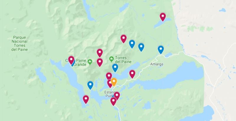
Download the map with all hikes, viewpoints and campsites in Torres del Paine
Do you like this article or are you planning on visiting Torres del Paine in Chile? Pin it to your Travel destination board to access it later >>
Location
Comments
Torres del Paine – day hikes for every hiker
